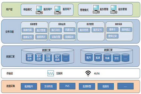

High safety performance GPS and BeiDou dual-mode positioning is combined to achieve real-time connectivity of ship navigation data. A full-process management is implemented for voyages, routes, energy consumption, etc., ensuring that the entire navigation process is made fully transparent and traceable. Furthermore, multi-dimensional monitoring, including video surveillance, is integrated, enabling active alerts in case of any anomalies and comprehensive safety assurance for ship navigation.
High integration Multiple functional modules—including vessel management, crew management, certificate and insurance management, and marine fuels and lubricants management—are integrated into one, realizing one-stop management, improving management efficiency, and helping shipping enterprises transform towards a digital and intelligent management model.
Intelligent event reminder A variety of intelligent reminder functions are set up, such as ship voyage dynamic reminders, equipment fault early warnings, and certificate expiration reminders. Important events and abnormal situations are promptly pushed to relevant personnel to facilitate early preparation for responses, avoid accidents or business delays, issue early warnings in a timely manner, and arrange maintenance and service.
System management flexibility The product features an optimal system administration backend, allowing shipowners and managers to flexibly configure user permissions according to their organizational structure and operational needs. Different departments and personnel in different positions can be precisely assigned permissions to operate, view, and edit specific functional modules, ensuring data security while enhancing management efficiency. For example, permissions can be set for crew members, maintenance personnel, and dispatch personnel according to their respective job scopes, avoiding unauthorized operations.
Data access convenience A dedicated edge access terminal is installed on the vessel to enable easy integration with various onboard sensors and equipment, greatly reducing the difficulty of data access. Regardless of the model of ship equipment, whether old or new, and differences in interface types, rapid and stable data collection can be achieved, providing basic support for subsequent analysis and processing for the platform.
Visual information management Utilizing technologies such as Geographic Information Systems (GIS) and big data visualization, various information including ship positions, routes, navigation status, and equipment operating parameters are presented in intuitive and easy-to-understand charts and maps. Managers can grasp the overall operational status of the ships at a glance, quickly identify potential problems and risks, and obtain intuitive basis for decision-making